


Les Chavants Charousse

Jean-Marc C
User
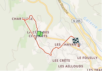

Length
3.4 km

Max alt
1232 m

Uphill gradient
102 m
Km-Effort
5.2 km

Min alt
1008 m

Downhill gradient
227 m
Boucle
No
Creation date :
2023-02-11 14:57:49.204
Updated on :
2023-02-11 16:06:34.71
50m
Difficulty : Easy

FREE GPS app for hiking
 SityTrail
IGN / Geographical institutes
SityTrail Plus
The world is yours!
About
Trail Walking of 3.4 km to be discovered at Auvergne-Rhône-Alpes, Upper Savoy, Les Houches. This trail is proposed by Jean-Marc C.
Positioning
Country:
France
Region :
Auvergne-Rhône-Alpes
Department/Province :
Upper Savoy
Municipality :
Les Houches
Location:
Unknown
Start:(Dec)
Start:(UTM)
326960 ; 5084982 (32T) N.
Comments